Exact date UK to bask in 30C heat as weather maps turn volcanic red
Parts of the UK could be heading for another spell of intense summer heat, with long-range forecasts suggesting temperatures may exceed 30°C in several areas in the second week of July.
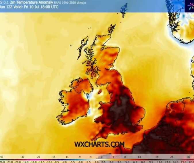
According to weather maps produced by WX Charts, Thursday, July 10, could bring widespread hot conditions across England. Forecasts suggest highs of around 31°C in Hull, Birmingham, and Bristol, while Manchester could reach approximately 30°C by the evening.
Elsewhere, temperatures are expected to remain warm but slightly lower, with the south coast seeing highs in the upper 20s. Wales could experience temperatures between 24°C and 27°C, Northern Ireland around 21°C to 22°C, and Scotland ranging from 16°C to 24°C.
The same forecasts indicate temperatures may begin rising from July 9 before peaking between July 11 and July 12, when some areas, including London, could see highs of up to 33°C. However, forecasts made this far in advance are subject to change.
Met Office Outlook
The Met Office currently provides detailed forecasts only up to July 5. Its latest predictions show temperatures reaching around 27°C in London, 23°C in Plymouth, 22°C in Cardiff, 19°C in Belfast, and 18°C in Aberdeen.
Looking further ahead, the Met Office's long-range outlook covering July 11 to July 25 suggests that high pressure is slightly more likely to dominate. This pattern typically brings calmer weather, with drier and more settled conditions across much of the country.
Record-Breaking Heatwave
The forecast follows an exceptional period of hot weather that recently affected the UK.
The Met Office confirmed that Friday became the hottest June day ever recorded in the UK after a provisional temperature of 37.3°C was measured in Santon Downham, Suffolk. This exceeded the previous day's 36.7°C recorded in Merryfield, Somerset.
Both temperatures surpassed the previous June record, which had stood since 1976, by more than 1 degree Celsius—a significant margin for national weather records.
Climate researchers have said that such extreme heat events are becoming increasingly likely due to human-driven climate change, making intense heatwaves more frequent than they were several decades ago.
Heat Warning Remains in Place
An amber warning for extreme heat remains in place across parts of southeast England and East Anglia until 9pm on Saturday.
Met Office chief forecaster Andy Page said temperatures are expected to be slightly lower than those seen during the peak of the recent heatwave, generally reaching the low 30s.
Weather Outlook for Next Week
The Met Office expects more changeable conditions during the coming week. Many areas will experience a mix of sunshine and cloud, while weather fronts moving in from the west are likely to bring periods of rain.
Five-Day Forecast
Saturday, June 27 – Wednesday, July 1
Showers, some potentially thundery, are expected across eastern and southeastern parts of England. Rain will gradually spread into Northern Ireland and western Scotland later in the day, while other regions enjoy sunny intervals. Although temperatures will ease compared with recent days, southeastern England is expected to remain the warmest part of the UK.

