Horror map reveals 10 worst places to live in UK if WW3 breaks out
An online postcode checker has identified ten UK council areas that it considers particularly vulnerable in a hypothetical global conflict. Gosport tops the reported list, followed by Portsmouth and Westminster.
Serhii Kashevko created the project, called Inspector Walls, using public information. Its results come with an essential qualification: the creator describes it as a thought experiment, rather than a prediction of where attacks will happen.
For residents, that distinction matters. A high score does not mean an area will be attacked, and a lower score does not guarantee safety.
The ten areas in the reported ranking
The following results appear in the supplied report about Inspector Walls. These are council areas rather than ten individual postcodes; Rushmoor includes Aldershot and Farnborough.
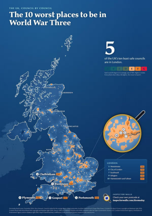
A tool allows Brits to enter their postcodes to see how at risk their council area is (Image: Inspector Walls )
10 most dangerous postcode areas.
As reflected in the map above, the 10 most dangerous areas are as follows:
Gosport (F, 67)
Portsmouth (F, 65)
Westminster (F, 65)
Cheltenham (F, 64)
Rushmoor, Aldershot and Farnborough (F, 64)
City of London (F, 63)
Southwark (F, 62)
Plymouth (F, 62)
Islington (F, 62)
Hammersmith and Fulham (F, 61)
How the postcode checker approaches risk
According to Kashevko’s explanation in the original report, the tool considers around a dozen factors. These include proximity to potential strategic targets, local terrain, weather conditions, and information from a property’s Energy Performance Certificate.
The model reportedly considers hills between a property and a potential target, alongside factors such as wind and rainfall. It also uses information about the building itself.
Combining these details produces a rating, but the rating's accuracy depends on the model's assumptions. Using public data does not, by itself, demonstrate that a tool can reliably predict the effects of a future conflict.
Why military and government centers feature prominently
The creator attributes many of the higher scores to nearby military, intelligence or government facilities.
In the supplied report, Gosport and Portsmouth are associated with naval infrastructure, while Plymouth’s position is linked to Devonport. Cheltenham’s inclusion is attributed to GCHQ, and Rushmoor’s to the Army’s presence around Aldershot.
The London entries are explained through their proximity to central government and other strategically important locations.
These explanations describe the model’s reasoning. They do not establish an official list of likely targets or prove that the named areas are Britain’s most dangerous places to live.
Emergency preparation has a wider purpose.
Separately, the UK Government’s Be Ready campaign encourages households to prepare for temporary disruption to everyday services.
Launched on 22 October 2026, the campaign includes advice about keeping a small supply of bottled water and non-perishable food, with preparation for three days of disruption at its center. Its stated focus includes severe weather and interruptions to electricity, water, phones and internet services. The campaign should therefore not be presented as evidence that a world war is imminent.
The Inspector Walls rankings may prompt discussion about geography and emergency planning. Their limits should remain equally visible: they describe one developer’s hypothetical assessment, and avoiding the ten listed areas does not guarantee safety.

