Climate expert issues most dire El Niño warning yet: ‘I am officially concerned’
From top government officials to local news meteorologists, warnings about the developing “super” El Niño in the Pacific Ocean have been consistent for several months now.
Experts say the data is clear: Surface temperatures along the equator are well above normal, raising the odds of an extraordinarily wet winter in California, which carries with it the potential for flooding, mudslides and coastal erosion.
The early effects of El Niño have already materialized.
Pacific hurricanes, most notably Hurricane Marie, produced pounding waves and storm surges that battered Southern California’s coastal communities. Tropical marine life, including hammerhead sharks, Chilean manta rays, whale sharks and Eastern Tropical Pacific orcas, are appearing in larger numbers, or, in the case of an Olive Ridley sea turtle that laid eggs in Huntington Beach, being seen for the very first time.
The arrival of rare marine life in Southern California is generally welcomed, but the possibility of destructive weather is ominous.
On Tuesday, Daniel Swain, a prominent climate scientist at UC Agriculture and Natural Resources, took to social media to issue his most alarming update yet on El Niño’s potential.
“Based on what I am seeing now, I am officially concerned,” Swain said, pointing to forecast models that show increasingly high confidence in a very wet California winter.
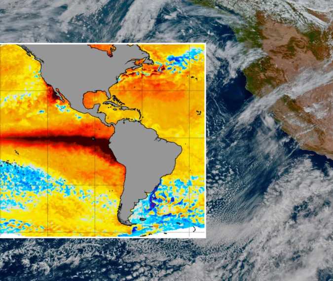
Sea surface temperatures in the tropical Pacific have surged past 3 degrees Celsius above average, as illustrated by a global map from the National Oceanic and Atmospheric Administration.
In an advisory last month, NOAA said El Niño will continue to strengthen through the end of the year, with a 75% chance of a “historic event” that surpasses the strength of all recorded El Niños dating back to 1950.
“We’ve never seen an event this big before in the context of our rapidly warming climate … The warning lights are flashing,” Swain said.
Last month, California Gov. Gavin Newsom preemptively declared a state of emergency – and representatives from the National Weather Service joined Los Angeles city officials on Monday to discuss El Niño’s potential impact on the region and to update preparedness measures.
“Very strong El Niño events increase the odds of dangerous weather and coastal conditions, including flash floods, burn scar debris flows, severe thunderstorms with damaging winds and tornadoes, coastal flooding, beach erosion and dangerous rip currents,” NWS Head Meteorologist Dr. Ariel Cohen warned.
Mayor Karen Bass said crews are actively clearing storm basins and drainage systems, and reinforcing hillsides that are susceptible to debris flows – wildfire burn scars, in particular.
Swain, like all climate scientists, stresses that El Niño only raises the likelihood of above-average precipitation – it is not a guarantee. Even so, he says the current models are aligned.
“I’ve never seen such high predictive confidence in a very wet California winter,” he said. “This kind of outlook is one reason why California’s pre-emptive emergency declaration, I think, is justified.”
Source: ktla.com