Map Shows Safest US States to Live During Nuclear War
As international tensions continue to rise, discussions about nuclear threats have become increasingly common. Questions about preparedness and survivability have sparked interest in research examining how different parts of the United States might be affected in a nuclear conflict.
One analysis, based on scientific modeling of nuclear fallout patterns, explored how various regions could be impacted if missile silo locations across the American heartland were targeted. The research focused on silo areas concentrated in states such as Montana, Wyoming, Colorado, Nebraska, and North Dakota—locations considered strategically significant.
Using simulated fallout projections, researchers estimated where radiation exposure might be lower under specific attack scenarios. Their calculations relied on projected cumulative radiation levels over four days, measured in grays (Gy), a standard unit used to assess absorbed radiation doses.
Areas With Lower Projected Exposure
Under an average modeling scenario, many states along the East Coast and parts of the Southeast showed lower estimated fallout exposure. These included much of New England, sections of the Mid-Atlantic, and states stretching south toward Florida and west into parts of the Midwest.
Additional western states—including California, Oregon, Washington, Arizona, and New Mexico—also appeared to experience reduced exposure levels in the model.
Estimated radiation doses in these lower-risk areas ranged from extremely low values up to roughly 0.5 Gy. By comparison, regions nearest the targeted missile fields showed significantly higher estimates, in some cases exceeding levels scientists consider potentially fatal.
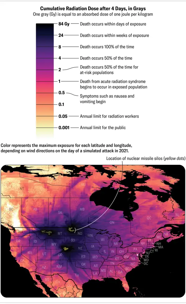
Photo: newsweek.com
Conditions Could Change Dramatically
Researchers also examined a more severe scenario based on specific atmospheric conditions and wind patterns on a given day. In that simulation, the list of less-affected states became shorter, though portions of the Northeast and Southeast still appeared to have lower projected exposure than much of the country
The study emphasized how strongly weather conditions influence the spread of fallout. Wind direction alone can dramatically alter which regions receive heavier contamination.
The scenarios assumed one or two nuclear warheads with explosive power around 100 kilotons—an estimated yield considered sufficient for attacks on hardened missile silos.
Experts Warn Against a False Sense of Security
Despite maps and rankings, specialists caution that identifying “safe” locations can be misleading.
Nuclear policy experts note that while communities near military infrastructure or strategic targets could face the earliest and most severe consequences, the wider effects of a nuclear exchange would extend far beyond blast zones.
Potential impacts could include long-term radiation exposure, environmental contamination, disruption of food and water systems, and widespread economic and social consequences.
Some researchers have also highlighted the possibility of a broader global effect known as nuclear winter. Large quantities of soot and debris entering the atmosphere could reduce sunlight, disrupt agriculture, and create food shortages affecting populations far from the original strike zones.
Others question whether missile silos would even be primary targets, suggesting major political and command centers could face greater risk in a real-world conflict.
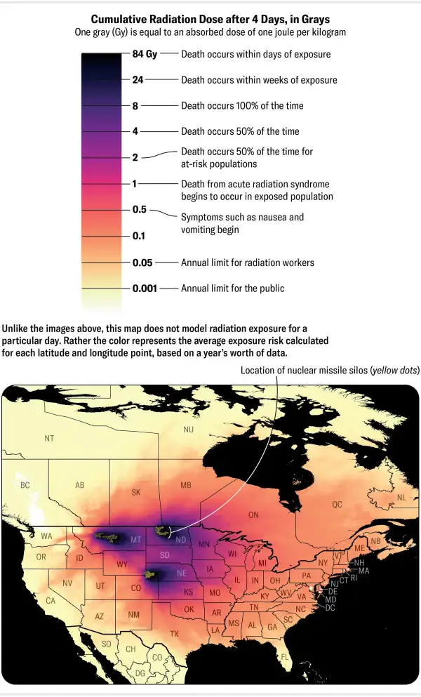
Photo: newsweek.com
The Bigger Picture
While simulations can help scientists understand potential outcomes, experts stress that no model should be interpreted as identifying a truly “safe” place during a nuclear war. The consequences of such a conflict would likely extend far beyond immediate impact zones and affect people worldwide.
For many researchers, the main takeaway is not where to relocate, but the reminder that preventing nuclear conflict remains far more important than planning for survival after one.